Coastal Resilience


While people typically associate the high winds that down trees and power lines as the most destructive part of severe storms, “wind speed doesn’t tell you enough about the kind of damage hurricanes will cause,” explains Robert S. Young, the director of the Program for the Study of Developed Shorelines at Western Carolina University in Cullowhee. “More common today are big fat storms pushing a lot of water in front of them.”
Increased rainfall and more intense and longer-lasting storms are trends that are likely to intensify as the planet continues to heat up, according to the Intergovernmental Panel on Climate Change. Such torrents overwhelm conventional storm-drainage systems, hurling overflows toward shorelines, bays, or river outfalls just as storm surges crash over bulkheads. The flooding in the lowest-lying areas is much more severe than historical norms—as Hurricane Harvey demonstrated in 2017 when it came to a stop over greater Houston, shattering records with as much as 50 inches of rain. And don’t be confused by how severe storms are measured: a 100-year event does not mean such storms will only happen once a century but that they have a 1 percent chance of -occurring in any given year. That’s why -communities can experience two or more “100-year” storms in the space of a few years. Yet stormwater systems are usually designed to manage only a 5- or 10-year storm, and, with more frequent severe storms, local drainage systems are falling behind.
Until recently, standard practice for coastal communities in the U.S. was to build protective shoreline barriers such as bulkheads (usually concrete, timber, or sheet piles) and revetments (sloped walls made of large, stacked rocks) intended to be permanent. This approach is often referred to as a “hard path” method because the barrier is fixed, but it loses value once overtopped, which, frighteningly, is happening much more often. And while bulkheads can be useful where there is little space along the shoreline, this type of engineered armor is now often considered a last resort, since it can exacerbate erosion and harm the rich ecological continuum between the waterfront and upland environments, leaving shorelines largely devoid of habitat. In recreational areas too, hard-path protections considerably diminish the visitor experience.
Instead, natural-system solutions that can adapt to changing conditions provide multiple benefits. These “soft path” tactics include dune systems, planted waterway edges that may be partially reinforced with structured terraces, constructed marshlands, and ponds. Natural-ized stream basins include elements, such as wider stream beds and oxbows, that slow the flow of water and hold it until conventional piped drainage systems catch up. These strategies, at neighborhood or even watershed scale, include “green infrastructure” practices that are already used across the country to augment older storm-drainage systems. Also referred to as low-impact development, these practices encompass green roofs, permeable surfaces, subsurface tank installations, linear bioswales, and bioretention basins to retain water (infiltrating it into the soil to keep it out of the storm-drainage system) or detain water (storing it or slowing its flow until peak flooding passes). Designing soft-path protections demands a team of specialists in hydrology and wetland ecology, but architects and landscape architects play a role in integrating these installations into sites and neighborhoods.
Such soft systems have succeeded in places like Puerto Rico, which was devastated by Hurricane Maria in 2017. The storm tested the 1.2-mile-long Parque del Litoral, a beach park in Mayagüez. It is a pioneering project combining shoreline protection and upland water management by New York–based Local Office Landscape and Urban Design working with local architect Javier Bonnin Orozco. It cut off old stormwater pipes that had previously dumped polluted runoff into the bay. Instead, day-to-day runoff is biologically treated in wetlands constructed inland of a dune and low enough to store a considerable amount of storm-surge water. Trees and shrubs were planted to help diffuse the energy of a storm surge, and the accompanying high winds. Parking and recreation spaces were installed with porous pavement to infiltrate runoff, reducing the drainage burden. The commercial street on the inland edge of the park was raised to direct surface runoff toward the wetlands. After Maria, local businesses reported that the park, which opened in 2010, protected their buildings. Streets turned into streams, but they flowed away from buildings and into the wetlands as designed. The park itself sustained little more than cosmetic damage.

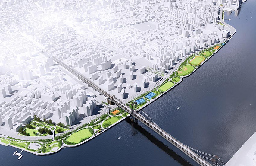
HIGHER GROUND A team that includes AKRF and BIG has developed a flood-protection scheme for 2.4 miles along New York’s Lower East Side (bottom). It calls for raising the elevation of an existing park about 8 feet (top).
Notice