This CE Center article is no longer eligible for receiving credits.
The days of designing for a discrete project are numbered. While creating socially sustainable environments that improve the health and well-being of community members is now a given, today's most forward-thinking architects are finding it their mission to go beyond their project in terms of both space and time—to consider, and even encourage, land use patterns in the surrounding area, and to anticipate, and even influence, future events and unexpected consequences. Best practice has become to design not only for the footprint of the project and its surrounding area, but also for the timeline of the property and the people who will use it in years to come. This article will examine the practices of land use planning, placemaking, and intelligent urbanism as they contribute to these goals by creating benefits at the individual and the community level. Also highlighted will be effective planning in action—three case studies that have embraced these practices.
Effective Planning Strategies
The fact that cities are compact, walkable, social places designed for people used to be a given. But over time, cities became more oriented to the demands of cars and commerce. As early as the 1960s, however, planners reacted. Thought leaders like Jane Jacobs and William H. Whyte advocated for cities that catered not just to cars and shopping centers but also to people. Lively neighborhoods and inviting public spaces held the key to successful cities, they maintained, with Jacobs cautioning that citizens should be watchful of what goes on in the streets and Whyte emphasizing the need for people-centered urban communities.
These models, as it turns out, have proven to be more humanistic, as well as healthier. In a recent study of the effects of street network design on public health, researchers at the University of Colorado Denver and the University of Connecticut1 found, not surprisingly, that older, more compact cities promote more walking and biking and are generally healthier than many newer communities. The study, co-authored by Norman Garrick, PhD, associate professor of engineering at the University of Connecticut, focused on 24 medium-sized California cities with populations ranging between 30,000 and just over 100,000, and examined them in terms of street network density, connectivity, and configuration. Researchers then investigated the correlations between street design and the local rates of obesity, diabetes, high blood pressure, heart disease, and asthma. The results showed that “increased intersection density was significantly linked to a reduction in obesity at the neighborhood level and in obesity, diabetes, high blood pressure, and heart disease at the city level.”2

Source: LEVENBETTS
New planning modalities think beyond the property line to determine—and even encourage—future land use patterns.
Today's planners have responded to these influences with mindful approaches to creating developments that support communities on a number of levels. Many contemporary and emerging modalities, from smart growth to new urbanism and transit-oriented development, are turning out the type of sustainable spatial arrangements that make communities walkable and promote the health, safety, and well-being of the populace. Comprehensive land use planning is a process to establish residents' community development goals, the result of which is a comprehensive plan that lays out land use policy over a wide geographical area and a long timeframe.
Placemaking, which is another way planners are more collectively and intentionally shaping the world, is finding its way into mainstream practice to better affect community health, social connectivity, economics, and sustainability. According to Project for Public Spaces, the movement encompasses the planning, design, management, and programming of public places and is strongly tied to community participation. Consequently, placemaking “facilitates creative patterns of activities and connections—cultural, economic, social, ecological—that define a place and support its ongoing evolution.”3
Source: LEVENBETTS
Today’s planners are creating developments that support communities on a number of levels.
Intelligent Urbanism—Ten Axioms
Intelligent urbanism, which, at its most basic level, recognizes that cities should be planned for future residents and accommodate the needs of future populations, is making an important contribution to planning philosophy and is worth exploring in more detail. The Principles of Intelligent Urbanism (PIU), a term coined by Professor Christopher Charles Benninger, are the key elements of the planning curriculum at the School of Planning, Ahmedabad, which Benninger founded in 1971. These principles were developed as an enhancement to traditional planning practices and are composed of ten axioms intended to guide the formulation of city plans and urban designs so as to reconcile and integrate diverse urban planning and management concerns.4 These axioms are summarized as follows:
Balance with nature. In short, intelligent urbanism states that urbanization should be in balance with nature. This axiom emphasizes the distinction between utilizing resources and exploiting them, and promotes environmental assessments to identify fragile zones, threatened ecosystems, and habitats that can be enhanced through conservation, density control, land use planning, and open space design. The ideal development will operate within the balance of nature, with a goal of protecting and conserving those elements of the ecology that nurture the environment.
Balance with tradition. This axiom calls for integrating planning and design considerations with existing cultural assets and respecting traditional practices and precedents of style. Respect for the cultural heritage of a place is important, as is traditional wisdom in the layout of human settlement and the symbols and signs that transfer meanings through decoration and motifs. Attention should be oriented toward historic monuments and heritage structures, and there should be respect for maintaining existing views and vistas.
Appropriate technology. Consistent with “small is beautiful” and the move to locally sourced resources, this principle advocates the use of construction materials and techniques, as well as infrastructure and project management systems that are compatible within their local contexts. For example, labor-intensive methods are appropriate where there are abundant craftspeople or where local economies suffer from high employment. Capital-intensive methods are more suitable in places with a surplus of funds or where the rapid deployment of new infrastructure provides enhanced opportunities to the local population.
Conviviality. The fourth principle espouses social contact through public domains, maintaining that vibrant societies have interactive, socially engaging spaces that offer numerous opportunities for gathering and meeting. Design can realize this goal. Society operates within hierarchies of social relations, which are space-specific. For example, places of solitude can be found in urban forests, hillsides, streams, gardens, or parks that are conducive to meditation and contemplation. Solitary activities in natural settings quiet the mind and help it to sort out the complexities of modern life and attain balance. These types of spaces, which can be defined by ceremonial gates and directional walls, create a place for the individual to mature through self-analysis and self-realization. Equally important are places for other types of interaction, notably those designed for friendship, households, neighborhoods, community, and city life. The axiom of “Conviviality” corresponds most directly with the contemporary planning concept of “Third Place,” as envisioned by Ray Oldenburg in his book The Great Good Place. Third Place embodies areas of social interaction outside the two primary areas of home and work.
Efficiency. Efficiency and cost-effectiveness are critical, as evidenced by a balance between the consumption of resources such as energy, time, and fiscal resources, and the optimum sharing of public land, roads, facilities, services, and infrastructural networks in order to reduce per household costs, while increasing affordability, productivity, access, and civic viability. Good city planning promotes alternative modes of affordable public transport, as well as medium- to high-density residential development keyed to social amenities, convenience shopping, recreation, and public services in compact, walkable, mixed- use settlements.
Human scale. Intelligent urbanism favors the pedestrian over the automobile. Ground-level, pedestrian-focused urban patterns are preferred, and urban villages are encouraged rather than a series of single-function blocks connected by highways.
Intelligent urbanism shares values with transit-oriented development; however, its goal is not restricted to replacing the automobile but to enrich the human condition and to enhance the realm of human possibilities. To that end, intelligent urbanism seeks to advance urban planning as the promotion of people-friendly places, pedestrian walkways, and public domains where people can meet freely in face-to-face contact, particularly in high-density situations with socially and economically diverse groups. Human scale can be a function of building masses that give way to open spaces, possibly using arcades and pavilions as buffers, sensitively mixing buildings with open spaces and employing natural materials.
Source: Diego Bermudez
Intelligent urbanism advocates planning for future residents and accommodates the needs of future populations.
Opportunity matrix. The city is viewed as an opportunity system that seeks to promote increased access to shared benefits within the urban system and with guaranteed access to education, health care, police protection, and justice before the law, potable water, and a range of basic services. Viewing the city as an opportunity system distinguishes intelligent urbanism from other urban philosophies. If urbanites face a variety of problems, there must be plentiful opportunities for resolution—with numerous channels to resolve problem areas. For example, when housing is a problem, opportunities for shelter could come through lodges, rented rooms, studio apartments, bedroom apartments, and houses, or through ownership, various tenancy arrangements, self-help, or incremental housing. A wide range of solutions should be possible wherever there is any problem. Another aspect of this principle is that the city is viewed in terms of processes. For example, rather than a blight on society, an economically depressed area is viewed as an opportunity for entry into the city by providing affordable shelter for new immigrant households, or as a springboard for self-development, or as a place that can be upgraded with basic services. Destruction of such settlements would create barriers to poor families, who may otherwise prosper and thus be able to make important contributions to the city.
Regional integration. Intelligent urbanism envisions the city as “an organic part of a larger environmental, socioeconomic, and cultural-geographic system, essential for its sustainability.” The region is the zone of influence, and it is inextricably linked with the city as the urban population migrates outward in response to opportunities in employment, shopping, entertainment, and other activities. The right planning at the regional level will benefit the city as it grows. Accordingly, intelligent urbanism plays a critical role in planning for the future and situations to come.
Balanced movement/complete streets. A well-functioning city should embrace complete streets, which are designed and operated to promote safety and access for all—pedestrians, bicyclists, motorists, and transit riders of all ages and abilities. A balance of transportation modes should include walkways, cycle paths, bus lanes, light rail corridors, underground metros, and automobile channels with, ideally, more capital-intensive transport moving in denser nodes, interchanging with low-technology options. Dense growth around mass transit corridors and major urban hubs is recommended, interspersed with smaller, though still dense, urban nodes. Besides providing access to services and facilities, modal split points can be social places that offer urban conviviality.
Institutional integrity. Intelligent urbanism recommends government that is transparent and held responsible. Facilitating the execution of honest objectives, intelligent urbanism attempts to streamline the proposal process by reducing mandated documentation and governmental barriers. The movement seeks to further the interests of the public—from upgrades of settlements with inadequate basic services to promoting innovative financing to a range of participants who can contribute to the city's development—and to limit the role of speculators in promoting large-scale urban development schemes for the benefit of limited interest groups.
The Benefits of Visionary Thinking
The integrity of these new planning modalities is all the more obvious when the principles and results are compared to a more limited or less thoughtful view of a project's scope. A limited approach would not take into account planning for the surrounding area or for future events or growth, nor would it embrace the flexibility to accommodate unexpected occurrences, such as changes in the economy, technology, fashion, and popular appeal.
On the other hand, a more inclusive approach would include considerations beyond the footprint of the property, as well as uses by people in years to come. A broader approach would also consider the life cycle of materials, including the flexibility of assembly and disassembly of materials associated with the site, so that the project can be easily adapted to future growth or changes.
Planning for New Orleans—Past and Future
Nowhere are the shortcomings of traditional planning more apparent than in New Orleans, where a combination of legal arrangements, unanticipated pressures, and resource mismanagement contributed to the perfect storm.
According to the U.S. National Library of Medicine of the National Institutes of Health,5 New Orleans and its environs are one of the most extensively engineered spots in the United States. The Mississippi River has been controlled almost exclusively to promote navigation. As far back as 1928, Congress authorized major levee improvements, and the U.S. Army Corps of Engineers began shoring up the flood control system, including levees, along the entire lower Mississippi and in New Orleans. While the construction of high levees curbed spring flooding along the lower stretches of the river, it also did away with wetlands, floodplains, and barrier islands, along with the natural wave and storm protection they provided. The Corps and other agencies have diverted significant portions of the river through a labyrinth of navigation lanes buttressed by 2,000 miles of levees that prevent it from sufficiently providing silt to the delta. By the 1950s, the rates of land loss along Louisiana's coast were dramatic. From the 1960s to the 1980s, the oil and gas industry had dredged some 10,000 miles of canals in coastal Louisiana, further compromising wetland areas. Extensive navigation channels support South Louisiana's port complex, one of the most important in the United States, and one from which most of the country's commodities such as corn, wheat, and soybeans are shipped around the world. In retrospect, this activity led to a series of overwhelmingly unforeseen circumstances.
In 2005, Hurricane Katrina hit and the levees failed, flooding some 80 percent of New Orleans and the surrounding area. It was among the five deadliest hurricanes ever witnessed in the United States. Due to failing hurricane surge protections, a lawsuit was brought against the Corps, which had designed and built the system of levees as required by the Flood Control Act of 1965. However, the sovereign immunity granted in the 1928 Flood Control Act made it impossible to hold the Corps financially liable.6
It is obvious that this piecemeal system of planning executed over several decades failed dramatically as a result of the outdated legal role of organizations such as the Corps combined with unanticipated pressures such as Katrina and climatic changes. Other contributors include the mismanagement of resources, notably the idea of channeling for ships to access the port and the removal of naturally occurring wetlands in the Gulf.
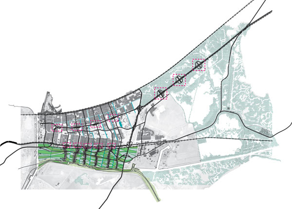
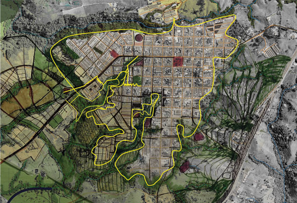
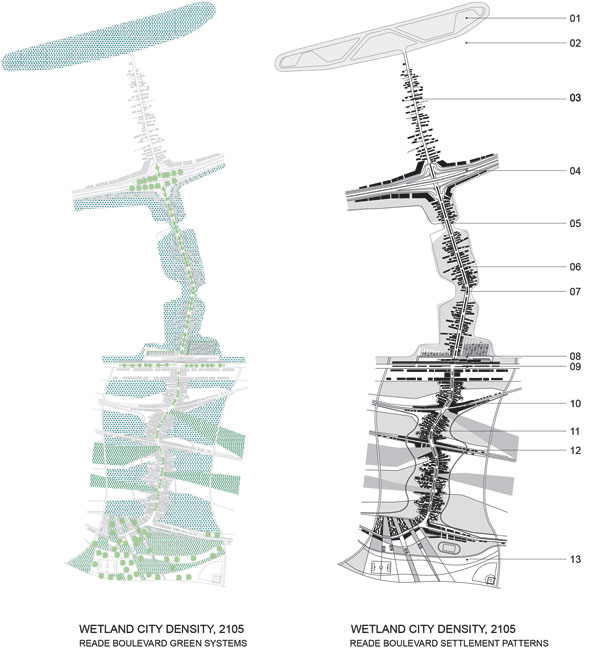
In the aftermath of Hurricane Katrina, architects and planners began to rethink future scenarios. Innovative architecture firm LEVENBETTS developed a visionary plan for a New Orleans community that had been hit hard by the hurricane. The Wetland City site was proposed for New Orleans East, one of the severely flooded Katrina areas, which was already endangered by the region's rising waters and subsiding land. The storm surge displaced a community of nearly 100,000 African Americans. The firm's Wetland City proposal for the community is based on the recognition that coastal Louisiana has lost significant land every year for the past 50 years and that even more coastline will recede in the future. The U.S. Geological Survey puts that number at 34 square miles annually and estimates that another 700 square miles could vanish over the next half century if no measures are taken to forestall the land loss.7 “We believed that an understanding of high and low water, how to remove water, and where to go when the flood comes is critical to planning in response to the flooded city,” say David Leven, AIA, and Stella Betts, partners at LEVENBETTS, noting that the firm's vision revolves around habitation on high ground and protection of wetlands. Among other elements in the plan, linear neighborhoods are separated by “a dense, productive green infrastructure of wetland agri- and aqua-culture, a continuation of public open space in the neighborhoods, and bioswales that remediate waste and process greywater.”8 While the LEVENBETTS plan was not executed, it demonstrates the kind of sustainable, future-oriented approach that is the hallmark of innovative planning efforts.
Source: LEVENBETTS
Wetland City is New York-based architecture firm LEVENBETT S’ plan for a New Orleans community that was devastated by Hurricane Katrina.
Best Practice in Action
Increasingly, landscape architects, architects, planners, and their clients are seeking to create places designed for long-term sustainability that meet community needs, mesh with the local infrastructure, balance the expectations of the community and other relevant stakeholders, as well as meet the principles of intelligent urbanism. As “placemakers,” planners and designers are creating a singular sense of place that achieves useful design outcomes. Community input is a strong part of the equation. An understanding of the stakeholders, their routines, their social and cultural heritages, technological abilities, economic status, and environmental and political leanings ideally inform the design process to create places that people will use and enjoy while contributing to their health, safety, and welfare.
Ballast Point Park—A Post-Industrial Waterfront Re-Imagined
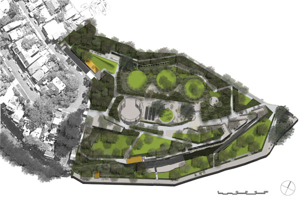
One notable example of placemaking is located along Sydney Harbor Australia at Ballast Point Park. Situated on the former Caltex oil production facility site, the park occupies the tip of Birchgrove Peninsula in the city's inner western harbor suburb of Balmain. The site has a rich history, stretching from Aboriginal use to the privately owned villa Menevia in the 1860s, then a quarry for ship ballast, and finally Caltex ownership from the 1920s until 2002. Landscape architecture and urban design firm McGregor Coxall developed the design concept that both appreciates the value that post-industrial sites can bring to the public and embodies regenerative approaches as opposed to merely curtailing environmental degradation.
Community input was incorporated through a significant consultation process undertaken between 2003 and 2005. The resulting design meshed several historical periods and used recycled materials in new and ingenious ways to create a distinctive, sustainable public park. The environmental program involved site-wide decontamination and bioswales to filter stormwater, wind turbines to generate energy, and the use of native trees, shrubs, and grasses. Keeping new materials to a minimum was important to the designers, who utilized demolished and recycled materials to build the new infrastructure, including the new gabion retaining walls, decks, and seating. Materials found on the rehabilitated site were used both structurally and aesthetically to enhance the historic identity of the site. According to the magazine ArchitectureAU, “…the exhilaration of moving up through the series of ramps and stairs and jutting terraces is interwoven with the pleasure of finding tiny sagas embedded in the massive, newly constructed gabion walls. Broken pottery, dented dials, and vast amounts of anonymous rubble from the reshaping of the site create a new material and spatial language for the park.” The magazine hails the fact that onsite materials were redeployed “rather than shifting the problem elsewhere.”9
Source: McGregor Coxall
Ballast Point Park is an adaptive reuse project on the site of a former industrial facility.
The Ballast Point Park project received numerous awards, including the Annual International Waterfront Centre Award, and was recently shortlisted for the Rosa Barba Landscape Prize as one of the ten most significant global landscape projects of 2014.
Planning at the Grassroots Level
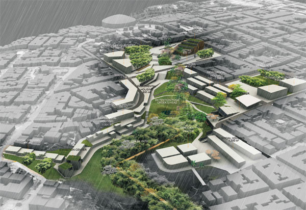
As opposed to traditional planning and its insular, inflexible approach, today's designers are exploring a more holistic vision. For example, University of Pennsylvania graduate student Diego Bermudez plans for the flexibility to accommodate social change while maximizing the use of open, shared spaces in his “Circasia: Engaging the Creeks” proposal.12 This project underscores the fact that to affect positive changes in current and future cityscapes, comprehensive land-use planning is not just the province of reputed architects in well-established firms with large budgets at their disposal. Instead, it can be successfully achieved even at the grassroots level in some of the world's remotest locations, including those with low-income residents and an adverse environmental history. A case in point is Circasia, a small coffee-growing town in a rich, natural environment in the Andes Mountains. Circasia is located in a territory that UNESCO has named a World Heritage Site and “Coffee Cultural Landscape.” The town and its environs are laced with creeks and ravines. Such water bodies were not taken into account by the Spanish laws of the Indies, and today, some 500 years later, they are still used for trash and wastewater disposal by settlements throughout Latin America.
Because of the steep topography surrounding Circasia's creeks and their flood risks, much of the adjacent land has remained relatively vacant, making it available for poorer communities to settle. The area has become susceptible to crime, too, as a result of its inaccessibility and the absence of watchful eyes on the surrounding green corridors.
Source: Diego Bermudez
Circasia’s steep topography has been a factor in keeping a substantial portion of the land vacant, but it also affords significant intervention opportunities to improve environmental and socioeconomic conditions in the town.
The Circasia master plan proposal aims to redefine the seam between the city and the creeks. A prime element of the plan is to improve the steep “edges” of the creeks. Potential areas of intervention were determined, including small housing developments, rural gateways, and coffee “institutions.”
It is the intent of the designer to create green corridors, thereby improving not only the visibility and connections across the creeks but also the access to mixed-use and open spaces. The design seeks to ameliorate environmental conditions while realigning the connection between the population settlements and the Circasia creeks, enabling wider enjoyment of the open space corridor and building a series of exciting public spaces. The creeks are seen as ways to promote social contact and to connect residents and the natural environment; open spaces proposed for the areas around the creeks will foster leisure activities in a natural setting. The ravines will afford recreational space for pedestrians and cyclists while simultaneously providing an opportunity to protect natural habitats and water resources. As the new vision takes hold, the adverse effects of human use and despoiling of natural resources will fade away, and “the natural processes of biodiversity” will replace them, with the creek promoting the coexistence of the urban and the natural worlds.
Planners believe that these interventions will strengthen Circasia and its natural resources, and that connections will be made between the creeks and the city's popular attractions such as the main plaza, the sports center, the museum, and the cemetery. The Parque de la Vida, which today is a trash strewn vacant lot, stands to become the site of popular festivals such as the Carnival de Libertad and the Cabalgatas, as well as the access point to a proposed new theater.
Planners have identified incremental housing as a way to enable low-income families to become homeowners. In time, the houses can be added on to and rented out, with owners receiving a steady source of income. A structural engineering advisory group will be implemented to help inexperienced builders.
Forward-Thinking Planning
Over the years, planning has evolved to become more forward-thinking, accommodating growth and anticipating and encouraging future land use patterns. Successful contemporary planning efforts incorporate the principles of sustainability and the integration of mixed land uses into communities as a critical component of achieving better places to live. Compact, walkable cities offer a range of benefits, from community cohesiveness and public health to security and local economies, all leading to the safety and well-being of current and future generations.
 |
Vectorworks Inc.
Vectorworks, Inc. is the developer of Vectorworks software, a line of industry-specific CAD and BIM solutions that help more than half a million design visionaries transform the world.
www.vectorworks.net |