Photo © Michael Mantese/EskewDumezRipple
Goldring Woldenberg Park, New Orleans
What is the purpose of the Great Lakes? Some 40 years ago, that was a question on my oral test for Canadian citizenship. I drew a blank. How can lakes have purpose? Surely they just are. Taking pity, the examiner leaned forward and murmured the answer she was looking for: “Transportation.” Over the span of the industrial age, use had become purpose—to the point where a country expected its new citizens to know that. But conflating the human use of a natural thing with its reason for being is a category error, and the mindset behind it has transformed the waterfronts of the world, disrupting natural systems and flows, infilling with infrastructure, and dumping contaminants.
Extensive though these interventions were, however, their own utility has turned out to be finite. Around the world, waterfronts are transforming yet again. And while early postindustrial waterfronts commonly focused on economic stimulus—hotels, restaurants, plazas, and nightlife—contemporary redevelopments increasingly seek to integrate human activity with ecosystem services and resurgent nature in a hopeful new balance.
In New Orleans and Toronto, two recent projects at different scales—the 6.3-acre Goldring Woldenberg Riverfront Park and the 60-acre Biidaasige Park, respectively—demonstrate contrasting takes on the shared theme of reintegration. Beyond major civic frontages, the 125-acre Manresa Wilds, in Norwalk, Connecticut, aims to redeem the site of a former coal-and-oil-fired power plant, one of hundreds of such landscapes along U.S. waterways, previously considered expendable, and now in dire need of repair.
After Hurricane Katrina, the design and planning team tasked with healing New Orleans’s connection with its riverfront identified multiple sites along a 6-mile stretch of the Mississippi’s Crescent Bend for potential redevelopment and then consulted the public about its priorities. “Parks and open space are what really caught people’s imagination and desire,” says Mary Margaret Jones, president and CEO of Hargreaves Jones, landscape architect for the project. That response echoed feedback Jones has heard over decades of work in waterfront redevelopment: “The public has been loud and clear that they want nature, they want respite, they want soft, green, organic relief from the urban environment,” she says. “And we just continue to be reminded of that over and over again.”
Photography: © Michael Mantese/EskewDumezRipple
Photography: © Jake Rosenberg
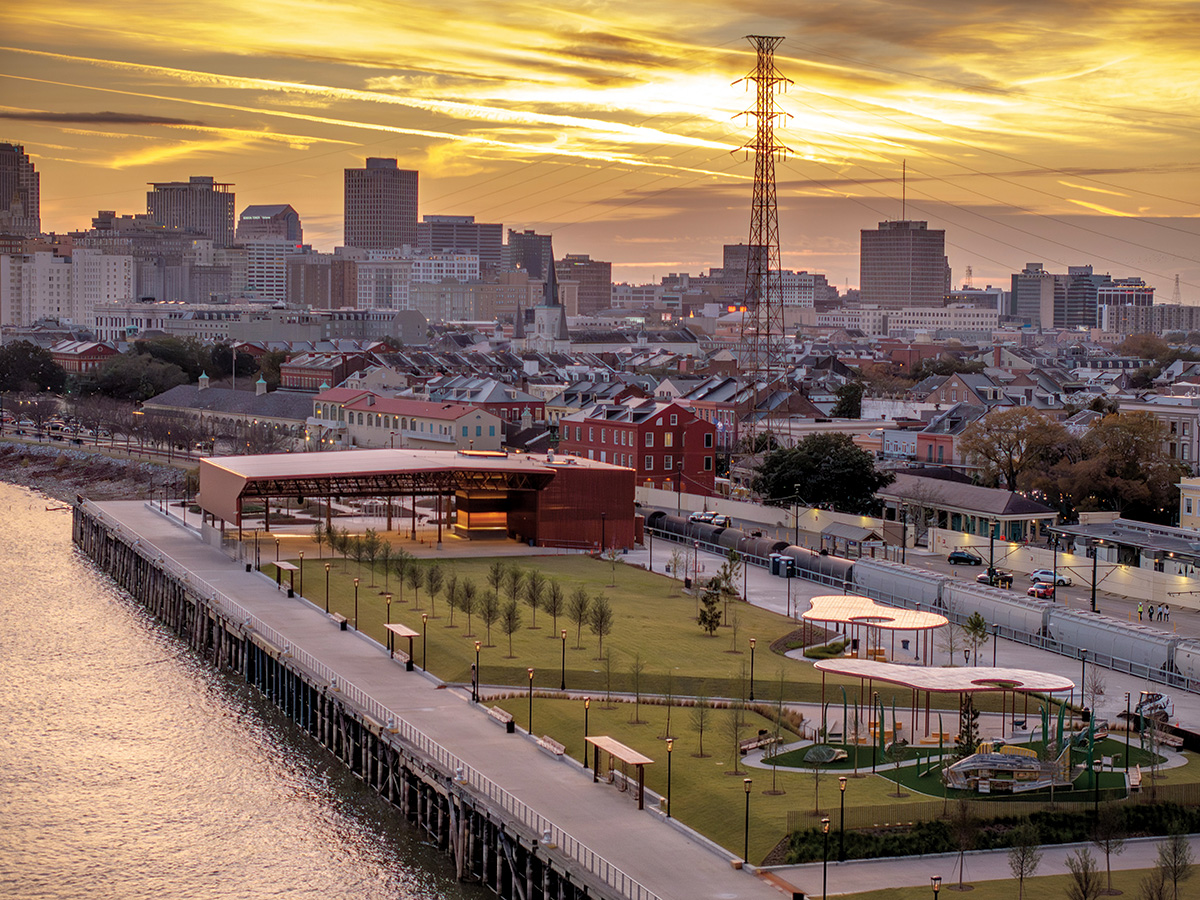
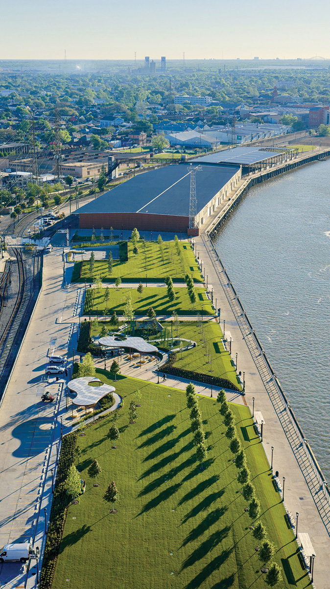
Near the French Quarter in New Orleans, Goldring Woldenberg Park reclaims a formerly industrial wharf.
Goldring Woldenberg Riverfront Park, which opened this April, is a key stage in the realization of the resulting master plan. Built on top of a former wharf, it completes a 2.25-mile run of connected parks along the city’s previously industrial edge, linking together historic neighborhoods, the heart of downtown, and the water. The scheme of the park is straightforward. “It’s complicated enough to put 4 feet of soil on a wharf so that you can grow giant trees and grass on the river,” says Christian Rodriguez, managing principal with EskewDumezRipple, architect for the project. Challenges included ensuring that the aging structure could support the weight of soil, trees, and crowds of visitors; creating a highly engineered soil system for intensive planting and foot traffic; managing drainage and waterproofing; and demonstrating that the project wouldn’t compromise critical river infrastructure. “Just doing that—not complicating it further,” Rodriguez says, “freed us to focus on the details: on delivering something simple, elegant, calibrated, and as close to perfect as it could be.”
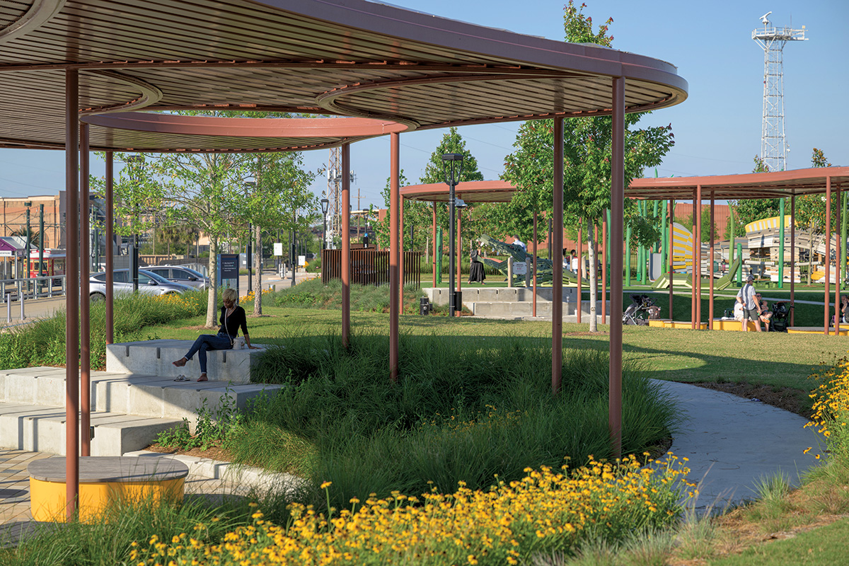
At one end of the park, earthen mounds planted with pollinator-friendly native species introduce subtle variations in moisture, exposure, drainage, and habitat, creating a miniature river-delta ecology; billows from a fog fountain cool passersby in hot weather while recalling the river beneath their feet. Two bays of the warehouse that previously occupied most of the site have been retained and reclad in rust-orange perforated box-rib panels, with much of the lower section left open. This airy pavilion now supports events from casual or organized gatherings to performances in front of thousands on a tree-lined lawn. When the lawn isn’t hosting festivals, its expanse of green provides New Orleanians with a place to relax. Shade trees, positioned directly over the concrete-filled steel posts of the wharf to minimize bending and shear loads, mirror the structure beneath. Beyond, a marsh-themed children’s play area and a paved plaza complete the scheme. “We’ve now seen music, we’ve seen kites, we’ve seen Frisbee, sunbathing, and picnicking,” Jones says. “There are poles where you can hang hammocks, and people are using them. There are food trucks. It’s fantastic how many people are walking and biking. And the whole park is lit at night.”
Creating a site that’s entirely human-made, especially one that’s standing in a river, forces a design team to think more comprehensively about what an ecosystem requires, Rodriguez says. The construction schedule included a Worming Day, for example, when the project’s owners, designers, and builders all gathered on-site to scatter worms—the specifics of which were detailed in the construction documents—into little trenches, jump-starting a crucial aspect of soil vitality on a site that worms would otherwise have been challenged to find. “On the flip side, it has been really lovely to see how quickly birds and pollinators have shown up,” Rodriguez says. “It is a very rich, robust, and diverse ecosystem up and down the Mississippi River corridor, and we’ve just provided another platform for that sort of life.”
At Goldring Woldenberg, social and ecological concerns are primary design drivers; at Toronto’s Biidaasige Park, goals expand to include infrastructural performance. “It’s a very different type of park for this city,” says Emily Mueller de Celis, a partner at Michael Van Valkenburgh Associates (MVVA), landscape architect and prime consultant on the project. “It’s a piece of green infrastructure in terms of flood protection, it’s ecological habitat, and it’s an immersion in nature within an intensely dense part of the city that has been cut off from the water for so long.”
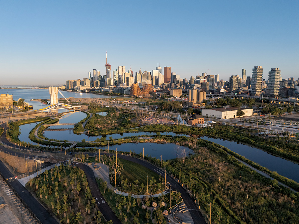
Image: © Waterfront Toronto
Biidaasige Park, in Toronto, is a key part of the Port Lands Flood Protection Project, featuring a renaturalized landscape where the Don River meets Lake Ontario.
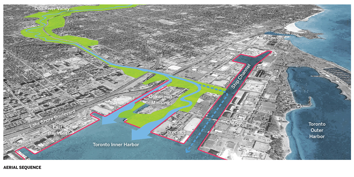
Image: © MVVA
Photo © Michael Mantese/EskewDumezRipple
Goldring Woldenberg Park, New Orleans
What is the purpose of the Great Lakes? Some 40 years ago, that was a question on my oral test for Canadian citizenship. I drew a blank. How can lakes have purpose? Surely they just are. Taking pity, the examiner leaned forward and murmured the answer she was looking for: “Transportation.” Over the span of the industrial age, use had become purpose—to the point where a country expected its new citizens to know that. But conflating the human use of a natural thing with its reason for being is a category error, and the mindset behind it has transformed the waterfronts of the world, disrupting natural systems and flows, infilling with infrastructure, and dumping contaminants.
Extensive though these interventions were, however, their own utility has turned out to be finite. Around the world, waterfronts are transforming yet again. And while early postindustrial waterfronts commonly focused on economic stimulus—hotels, restaurants, plazas, and nightlife—contemporary redevelopments increasingly seek to integrate human activity with ecosystem services and resurgent nature in a hopeful new balance.
In New Orleans and Toronto, two recent projects at different scales—the 6.3-acre Goldring Woldenberg Riverfront Park and the 60-acre Biidaasige Park, respectively—demonstrate contrasting takes on the shared theme of reintegration. Beyond major civic frontages, the 125-acre Manresa Wilds, in Norwalk, Connecticut, aims to redeem the site of a former coal-and-oil-fired power plant, one of hundreds of such landscapes along U.S. waterways, previously considered expendable, and now in dire need of repair.
After Hurricane Katrina, the design and planning team tasked with healing New Orleans’s connection with its riverfront identified multiple sites along a 6-mile stretch of the Mississippi’s Crescent Bend for potential redevelopment and then consulted the public about its priorities. “Parks and open space are what really caught people’s imagination and desire,” says Mary Margaret Jones, president and CEO of Hargreaves Jones, landscape architect for the project. That response echoed feedback Jones has heard over decades of work in waterfront redevelopment: “The public has been loud and clear that they want nature, they want respite, they want soft, green, organic relief from the urban environment,” she says. “And we just continue to be reminded of that over and over again.”
Photography: © Michael Mantese/EskewDumezRipple
Photography: © Jake Rosenberg
Near the French Quarter in New Orleans, Goldring Woldenberg Park reclaims a formerly industrial wharf.
Goldring Woldenberg Riverfront Park, which opened this April, is a key stage in the realization of the resulting master plan. Built on top of a former wharf, it completes a 2.25-mile run of connected parks along the city’s previously industrial edge, linking together historic neighborhoods, the heart of downtown, and the water. The scheme of the park is straightforward. “It’s complicated enough to put 4 feet of soil on a wharf so that you can grow giant trees and grass on the river,” says Christian Rodriguez, managing principal with EskewDumezRipple, architect for the project. Challenges included ensuring that the aging structure could support the weight of soil, trees, and crowds of visitors; creating a highly engineered soil system for intensive planting and foot traffic; managing drainage and waterproofing; and demonstrating that the project wouldn’t compromise critical river infrastructure. “Just doing that—not complicating it further,” Rodriguez says, “freed us to focus on the details: on delivering something simple, elegant, calibrated, and as close to perfect as it could be.”
At one end of the park, earthen mounds planted with pollinator-friendly native species introduce subtle variations in moisture, exposure, drainage, and habitat, creating a miniature river-delta ecology; billows from a fog fountain cool passersby in hot weather while recalling the river beneath their feet. Two bays of the warehouse that previously occupied most of the site have been retained and reclad in rust-orange perforated box-rib panels, with much of the lower section left open. This airy pavilion now supports events from casual or organized gatherings to performances in front of thousands on a tree-lined lawn. When the lawn isn’t hosting festivals, its expanse of green provides New Orleanians with a place to relax. Shade trees, positioned directly over the concrete-filled steel posts of the wharf to minimize bending and shear loads, mirror the structure beneath. Beyond, a marsh-themed children’s play area and a paved plaza complete the scheme. “We’ve now seen music, we’ve seen kites, we’ve seen Frisbee, sunbathing, and picnicking,” Jones says. “There are poles where you can hang hammocks, and people are using them. There are food trucks. It’s fantastic how many people are walking and biking. And the whole park is lit at night.”
Creating a site that’s entirely human-made, especially one that’s standing in a river, forces a design team to think more comprehensively about what an ecosystem requires, Rodriguez says. The construction schedule included a Worming Day, for example, when the project’s owners, designers, and builders all gathered on-site to scatter worms—the specifics of which were detailed in the construction documents—into little trenches, jump-starting a crucial aspect of soil vitality on a site that worms would otherwise have been challenged to find. “On the flip side, it has been really lovely to see how quickly birds and pollinators have shown up,” Rodriguez says. “It is a very rich, robust, and diverse ecosystem up and down the Mississippi River corridor, and we’ve just provided another platform for that sort of life.”
At Goldring Woldenberg, social and ecological concerns are primary design drivers; at Toronto’s Biidaasige Park, goals expand to include infrastructural performance. “It’s a very different type of park for this city,” says Emily Mueller de Celis, a partner at Michael Van Valkenburgh Associates (MVVA), landscape architect and prime consultant on the project. “It’s a piece of green infrastructure in terms of flood protection, it’s ecological habitat, and it’s an immersion in nature within an intensely dense part of the city that has been cut off from the water for so long.”
Image: © Waterfront Toronto
Biidaasige Park, in Toronto, is a key part of the Port Lands Flood Protection Project, featuring a renaturalized landscape where the Don River meets Lake Ontario.
Image: © MVVA
Beginning in the 1880s, the site of Biidaasige Park was one of the largest marshes of the Great Lakes system. Then it was filled and industrialized, and the mouth of the Don River channelized and forced through a 90-degree bend as it entered Lake Ontario. Over time, as industrial uses waned and redevelopment pressures mounted, the resulting floodplain left a broad swath of Toronto’s eastern waterfront—including disused industrial lands, existing neighborhoods, and key infrastructure corridors—in a decades-long planning limbo. With climate change bringing more frequent, heavier storms and rising lake levels, the need to plan was growing rapidly more urgent. In response, the Port Lands Flood Protection Project—one of the largest and most complex civil engineering initiatives in North America—has rebuilt and renaturalized the river mouth. Opened in 2025, with an additional 10 acres completing this year, Biidaasige Park, located along both sides of the river, is an integral part of the solution.
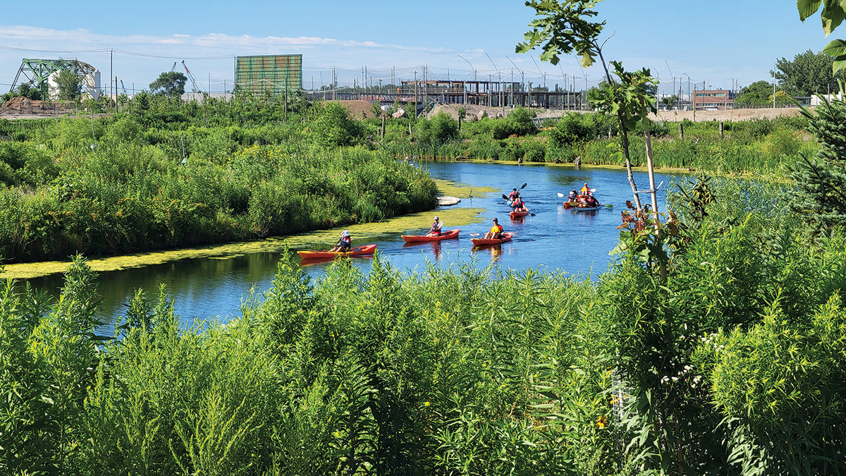
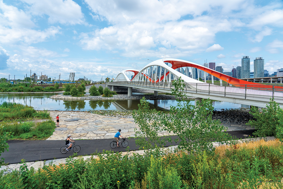
A now undulating watercourse flows through new wetlands, where canoeists and kayakers can paddle, bird-watchers can loop around the rich habitat, and anglers can set up at the water’s edge. There is a nature-play area, a water-play structure, picnic sites, and an art trail. An event lawn and historic fire hall accommodate a range of programming. Throughout the park, signage by an Indigenous-owned and -led design consultancy, NVision Insight Group, interprets the story of the place up to and including the creation of the contemporary landscape. Cycling paths connect the park to Toronto’s larger cycling network.
Photography: © MVVA
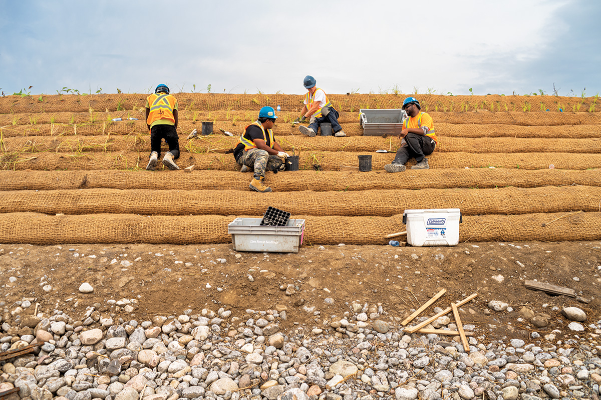
At Biidaasige, a meandering watercourse flows through wetlands (above), cycling paths connect to the city’s network (below), and native plants help stabilize new topography.
Photography: © Vid Ingelevics and Ryan Walker
Photography: © Vid Ingelevics and Ryan Walker
Waterfront Toronto, the tri-governmental entity responsible for the long-term redevelopment of the Port Lands, has a policy of “leading with landscape,” says Shannon Baker, the agency’s project director for parks and the public realm; parks and streetscapes are built before adjacent development. In addition to manifesting the agency’s rigorous design mandate, she says, there’s a strong economic case for building the public domain first, so that people can see the quality of what they’re buying into. Early studies projected a five- to sixfold return in private investment catalyzed by public funds.
As at Goldring Woldenberg, nature’s return to Biidaasige has been swift. When excavations during construction exposed the level of the lost marsh, seeds dormant for more than 100 years under more than 20 feet of fill began sprouting. Identified by University of Toronto ethnobotanists as hardstem bulrush, a crucial species in shoreline stabilization and wildlife habitat, the plants were “rematriated” into the park’s new wetlands and similar habitat nearby. Peat from the marsh level was also salvaged and reused in the wetlands in the hope that it contained seeds that will sprout new life. In the year since the park opened, ongoing monitoring by the Toronto and Region Conservation Authority has identified 26 different species of fish, including threatened species of American eel and the first documented Atlantic salmon in 14 years, and 19 native breeding bird species, including seven of conservation concern. “This whole story is one of reconciliation, restoration, and bringing life back to a place that was struggling because of what was historically done to it,” Baker says.
Goldring Woldenberg and Biidaasige parks both benefited from being valuable and emblematic front-porch sites for major cities. Manresa Wilds, on the other hand, demonstrates that less prominent postindustrial waterfronts also need, deserve, and are capable of reinvention. “All of society has benefited from these sites,” says Kate Orff, founding principal of Scape, landscape architect for the project. “But now the legacy of them somehow seems beyond the ability of our economic structure to meet.” What these places need, she says, is the programmatic mix most likely to succeed on a given site
and a “coalition of the willing” to achieve it.
At Manresa, a philanthropic initiative led by a local couple is behind the transformation of a shuttered power-plant site into a publicly accessible landscape with restored forests, coastal habitats, and a variety of year-round spaces to support the appreciation and enjoyment of them. When completed, between 2032 and 2035, the park will offer almost two miles of reopened shoreline—including a beach-front promenade, kayak terrace, and pier—and the site’s industrial-scale structures will be adapted by the project’s architect, Bjarke Ingels Group, for new uses, such as a civic hub, a community pool, and a research field station.
Over the decades that the 125-acre Manresa Peninsula was cordoned off, it developed a distinctive ecology: a birch forest grew on its vast coal-ash dump, and wildlife—turkeys, deer, the occasional coyote—moved in. Ospreys nest along the rocky coast. Wetlands emerged from the topography of roads and earthworks. Although the site is heavily contaminated from its decades of industrial use, rather than clearing it and starting anew, the design works with the accidental ecosystem. “Perhaps I’m romantic, but this entire forest that grew through neglect, and survived against all odds, gives people a sense of nature’s power to thrive despite everything we’ve done,” Orff says. “The idea of clear-cutting it didn’t seem like the right thing to do.”
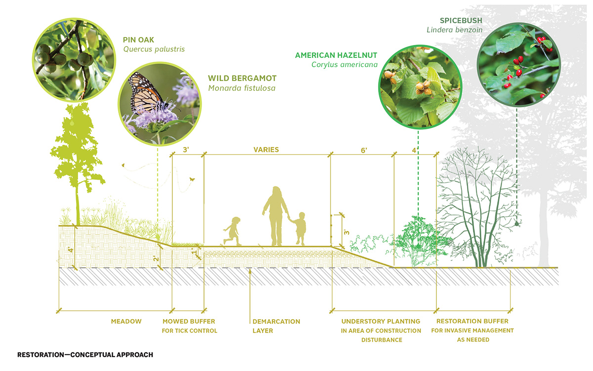
Image courtesy SCAPE
A restoration plan for Manresa Island (above), in Norwalk, Connecticut, works with ecosystems that have emerged since the site’s power plant (below) shuttered in 2013.
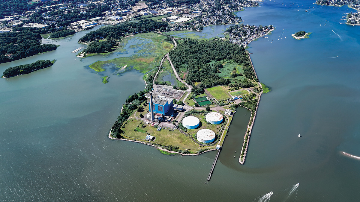
Photo courtesy Manresa Island Corporation
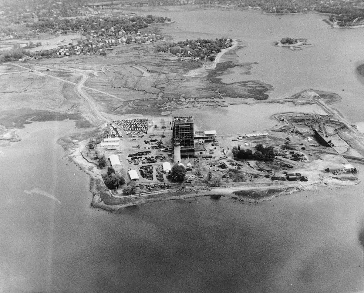
Photo courtesy Manresa Island Corporation
Instead, the scheme takes a strategic approach, using two main methods for making the contaminated site safe for visitors—excavate and remove or cap in place—and, unusually, combining them, in what Orff calls a mosaic approach. “The design challenge is matching the contaminant, the remedial action, and the public space outcome,” she says.
For example, in a choreography of cut-and-fill, polluted soil and sediment from upland areas and marshlands are being reused to create desired topography elsewhere on the site—such as a sloping substrate for a lawn between the former boiler building and the shore—and capped with clean fill. In the forest, the fly-ash dump has been left in place and trails lifted above it on what are, essentially, linear caps: berms of clean fill at varying heights above grade, their sloping sides serving as the base for a native-plant restoration project. Discreet use of fencing completes the suite of strategies for keeping people and pollutants apart.
A similarly economical approach informed the selection of sites for programmatic elements that require cleared ground—activities such as education, ecology, and gathering—are located in areas that had been overrun with phragmites, an invasive reed that crowds out native species.
The first phase of the project, “Northern Forest,” is scheduled to open in the spring of 2027. Encompassing 28 acres of the site’s interior, it will feature nature trails, meadows, and outdoor classrooms. In the meantime, with researchers from universities and other institutions already investigating the landscape’s postindustrial ecology, Manresa’s new life as a place of learning and discovery, as well as pure enjoyment, has already begun. Together, these three projects—Goldring Woldenberg, Biidaasige, and Manresa—manifest fresh thinking about postindustrial waterfronts, turning degraded remnants into ecological, social, cultural, and infrastructural commons.
Supplemental Materials
"
Manresa Island Masterplan,” 2025; Manresa Island Corporation.